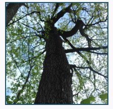
Mapping the extent and intensity of urban forestry activities
Urban forestry has over a 50 year-long history in Canada. The term “Urban Forestry” was coined at the Daniels Faculty’s Forestry, University of Toronto in 1965 (Jorgensen, 1993). Over the years, Urban Forestry (UF):
- Has evolved and expanded
- Has been practiced, with different intensity, from small towns to large metropolitan areas
- Has been embedded in various municipal departments and is practiced under different labels
- Includes a wide range of elements, from policies and by-laws, diverse management and stewardship activities to spatial planning, and conservation of urban forests
- Consists of diverse elements that are often hidden within other disciplines and municipal activities
As a result, the extent and intensity of urban forestry activities across Canada’s urban municipalities is not known and is larger than what is typically perceived.
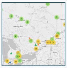
To address these gaps, this project aims to capture and map urban forest activities and use that information to assess the state of urban forestry and stewardship activities across Canadian municipalities.
Click here to download the Information Flyer (PDF): Measuring Footprint of Urban Forestry in Canada
Click on titles for web links:
The project is funded by Mitacs and Tree Canada, which enabled Yuki Yung, a Master of Forest Conservation (MFC) student at the Daniels Faculty’s Forestry, University of Toronto to become involved in this research and to further focus on tree protection in Ontario for her MFC capstone project.
The project is led by Dr. Danijela Puric-Mladenovic of the Daniels Faculty’s Forestry with support and guidance from Dr. Adrina C. Bardekjian, Tree Canada and Peter Wynnyczuk, Ontario Urban Forest Council.